3D Laser Scanning & As-Built Documentation Across the UAE
Capture every millimetre of your existing building or site with our professional LiDAR 3D laser scanning service. We deliver accurate point clouds, as-built drawings, and scan-to-BIM Revit models for fit-out, MEP coordination, refurbishment, and heritage projects throughout the UAE.
Comprehensive 3D Laser Scanning Solutions
Our end-to-end 3D laser scanning service combines state-of-the-art LiDAR hardware with expert post-processing to deliver the accurate, authority-ready documentation your project demands.
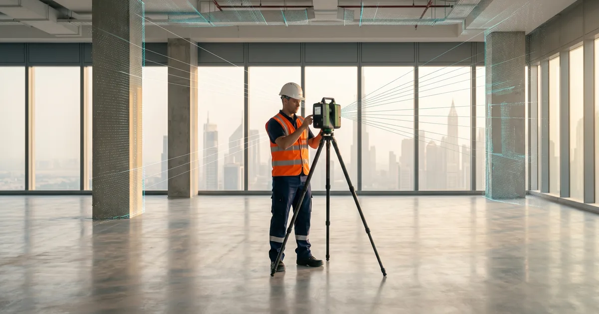
LiDAR 3D Laser Scanning
We deploy high-specification terrestrial LiDAR scanners to capture dense, accurate point clouds of buildings, infrastructure, and industrial facilities in a single site visit.
Point Cloud Capture & Processing (.RCP)
Raw scan data is registered, cleaned, and exported as fully indexed .RCP point cloud files — ready for immediate use in Revit, AutoCAD, and other industry platforms.
As-Built 2D Drawings (.DWG / .PDF)
Our engineers extract precise as-built floor plans, sections, elevations, and reflected ceiling plans from the point cloud and deliver them as editable .DWG and presentation-ready .PDF sets.
Scan-to-BIM / Revit Models
We build LOD 200–350 Revit models directly from the point cloud, creating intelligent BIM assets for design development, MEP coordination, clash detection, and facility management.
Millimetre Accuracy & QA
Every survey is validated against established control points and undergoes a rigorous internal QA review, ensuring positional accuracy within ±2 mm across the full extent of the scan.
Fast Turnaround & UAE-Wide Coverage
Our mobile scanning teams cover all seven emirates. Most projects receive preliminary deliverables within 48 hours of scanning and final certified drawings within the agreed programme.
3D Laser Scanning Process
We follow a structured four-stage workflow that guarantees data quality, full site coverage, and on-time delivery — from the first site visit to the final BIM or drawing package.
Site Survey & Scan Planning
Before mobilising equipment, our team conducts a thorough site assessment and prepares a detailed scan plan that ensures complete coverage with no shadowing or data gaps.
- Review of existing drawings, access constraints, and project brief
- Establishment of a local control network for accurate georeferencing
- Scanner placement strategy to achieve full 360° coverage of every space
On-Site 3D Laser Scanning
Our certified surveyors deploy LiDAR scanners across the site, capturing millions of data points per second to produce a dense, high-resolution 3D record of all existing conditions.
- High-density LiDAR scanning from multiple registered stations
- HDR photography capture for texture-mapped point cloud visualisation
- Real-time field checks to confirm coverage targets are met before demobilisation
Point Cloud Registration & Processing
Back in the office, raw scan data from all stations is registered together into a single unified point cloud, cleaned, colour-mapped, and structured for downstream use.
- Automated and manual scan registration to achieve sub-millimetre alignment
- Noise filtering and point cloud densification for clean, usable data
- Export to .RCP, .E57, or client-specified formats with full metadata
As-Built Drawings & BIM Deliverables
Our CAD and BIM teams extract the required deliverables directly from the registered point cloud, producing accurate, fully annotated documentation tailored to each project's scope.
- 2D as-built drawings (floor plans, sections, elevations) in .DWG and .PDF
- Revit scan-to-BIM models at the agreed LOD with all major elements modelled
- Final QA review and delivery with a measurement accuracy report
Where We Apply 3D Laser Scanning
From retail fit-outs to industrial plants, our 3D laser scanning service eliminates guesswork, reduces abortive design work, and provides an authoritative as-built record for any building type.
Retail & Commercial Fit-Out
Accurate as-built drawings eliminate costly surprises during fit-out by giving designers and contractors an exact record of the space before a single line is drawn.
- Precise floor plans and ceiling scans for shopfront and interior design coordination
- Column grids, beam soffits, and slab profiles captured with millimetre fidelity
- Clash-free MEP coordination from day one of the fit-out design process
MEP Coordination & Clash Detection
Integrating a scan-to-BIM model into the MEP coordination workflow captures what is actually built — not what was originally designed — preventing clashes before installation begins.
- Existing MEP routes, duct banks, and pipe runs captured as-built
- Revit MEP model overlaid on architectural and structural scan data for clash detection
- Revised coordination drawings issued against verified existing conditions
Heritage & Existing-Condition Documentation
Highly detailed 3D records preserve the geometry, fabric, and character of heritage structures and provide a reliable baseline for refurbishment and adaptive reuse projects.
- Full interior and exterior capture of historic buildings with sub-centimetre accuracy
- Textured 3D models suitable for conservation reports and authority submissions
- Comparison scans to monitor structural movement or settlement over time
Industrial & Warehouse Facilities
Large-scale industrial environments — warehouses, plant rooms, and process facilities — are scanned efficiently in a single mobilisation, delivering complete as-built documentation for capital projects and maintenance planning.
- Rapid, full-volume scanning of high-bay warehouses and production halls
- Accurate pipe-rack, structural-steel, and equipment-layout documentation
- As-built records for facility expansion, plant modification, and safety compliance
Why Choose Our 3D Laser Scanning Service
Choosing Optimal Engineering Consultants for 3D laser scanning means measurable improvements in accuracy, coordination, and project efficiency from day one.
Millimetre-Level Accuracy
LiDAR technology captures existing conditions with ±2 mm positional accuracy, eliminating the measuring errors and omissions that plague manual surveys.
Fewer Site Revisits
A single comprehensive scan session records everything — geometry, fixtures, and services — reducing the need for repeated site visits and minimising disruption to occupants.
Faster Design Development
Designers work directly from the verified point cloud or BIM model, cutting weeks off as-built survey time and accelerating the entire design programme.
Fewer RFIs and Site Clashes
Accurate as-built data fed into BIM coordination models dramatically reduces field clashes, change orders, and costly requests for information during construction.
Authority-Ready Documentation
Our as-built drawing packages are produced to UAE authority standards — DM, DDA, and relevant municipality formats — supporting smooth submission and approval.
Full UAE Coverage
With mobile survey teams based in Dubai and available across all seven emirates, we mobilise quickly and deliver consistently — wherever your project is located.
Ready to Capture Your Site in Precise 3D?
Contact our team to discuss your as-built survey requirements. We will advise the best scanning approach, agree on deliverables, and mobilise across the UAE at short notice.